📍New Delhi | 12 May, 2026, 8:13 PM
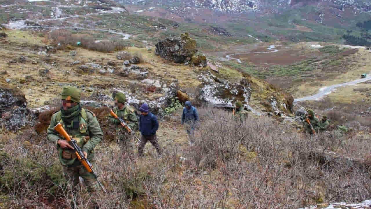
Arunachal LAC GSI Survey: A team of Geological Survey of India (GSI) recently visited in the border areas of Arunachal Pradesh. The GSI team visited forward areas with the Gazraj Chore of the Indian Army under the Eastern Command. The entire mission took place in sensitive areas involving India-China border i.e. LAC, where roads, bridges, tunnels and military infrastructure are being built in the past few years.
Garage Core According to the information released on behalf of GSI, this team was led by the Deputy Director General Dr. Pankaj Jaiswal and Director D.P. Dungwal. The team studied land stability, landslide risk and hard rock mapping by visiting the forward area. The team also met Gazraj Kor’s General Officer Commanding Lt. General Neeraj Shukla.
During this period, there were detailed discussions about Sustainable Infrastructure and Land Management in border areas. This joint activity of the Army and the GSI has taken place at a time when India is strengthening the Border Infrastructure in the Northeast much faster than ever.
Arunachal LAC GSI Survey: What GSI team was doing
The main work of the team of GSI was to understand the geological structure of the hillsides. It is seen in which Elaka is more susceptible to landslide, where the ground is weak and in which areas it will be safe to build a road or military structure.
टीम ने जिन इलाकों का दौरा किया, वे ज्यादातर हाई एल्टीट्यूड और फॉरवर्ड एरिया माने जाते हैं। वहां सैनिकों ने टीम को ऊंचाई वाले कठिन इलाकों तक पहुंचाया। गजराज कोर ने बर्फ से ढके पहाड़, चट्टानी क्षेत्र और हाई एल्टीट्यूड झीलों के फोटो भी जारी किए हैं।
जीएसआई की तरफ से “हार्ड रॉक मैपिंग” भी की गई। जिसमें पहाड़ों की चट्टानों की गुणवत्ता और मजबूती का अध्ययन किया जाता है। इसमें यह देखा जाता है कि कौन सी चट्टानें सड़क, बंकर या पुल निर्माण के लिए उपयुक्त हैं और कौन सी जगहें भूस्खलन का खतरा पैदा कर सकती हैं।
A Geological Survey of India (GSI) team, led by DDG (NER) Dr Pankaj Jaiswal and Director Shri D. P. Dangwal, conducted assessments of landslide risks, terrain stability, hard rock mapping and recce of lakes in forward areas to support resilient infrastructure development in… pic.twitter.com/hSNchKnqbR
— Gajraj Corps – Indian Army (@GajrajCorps_IA) May 11, 2026
सेना को क्यों पड़ी इसकी जरूरत
अरुणाचल प्रदेश और पूर्वोत्तर के कई इलाके बेहद संवेदनशील माने जाते हैं। यहां भारी बारिश, बादल फटना, भूकंप और लैंडस्लाइड आम बात है। मानसून के दौरान कई बार सड़कें टूट जाती हैं और सेना की सप्लाई लाइन प्रभावित हो जाती है।
भारत-चीन सीमा के पास इंफ्रास्ट्रक्चर तेजी से बढ़ाने के लिए ऑल वेदर रोड, सुरंग और नए सैन्य ढांचे बनाए जा रहे हैं। लेकिन पहाड़ी इलाकों में निर्माण करना आसान नहीं होता। अगर पहाड़ की भू-संरचना को समझे बिना निर्माण किया जाए तो कुछ समय बाद सड़क धंस सकती है या लैंडस्लाइड से टूट सकती है।
इसी वजह से सेना अब वैज्ञानिक तरीके से बॉर्डर इंफ्रास्ट्रक्चर तैयार कर रही है। जीएसआई की टीम उसी प्रक्रिया का हिस्सा मानी जा रही है।
सूत्रों का कहना है कि केवल सड़क बनाना काफी नहीं है, उसे हर मौसम में चालू रखना ज्यादा बड़ी चुनौती है। खासकर उन इलाकों में जहां सैनिकों और सैन्य वाहनों की आवाजाही लगातार बनी रहती है।
गलवान के बाद तेजी से बदली रणनीति
East Ladakh में 2020 के गलवान संघर्ष के बाद भारत ने सीमा क्षेत्रों में इंफ्रास्ट्रक्चर निर्माण की रफ्तार काफी बढ़ा दी थी। लद्दाख से लेकर अरुणाचल प्रदेश तक कई नए प्रोजेक्ट शुरू किए गए।
सड़क, पुल, एडवांस लैंडिंग ग्राउंड, टनल और बॉर्डर गांवों के विकास पर विशेष फोकस किया गया। केंद्र सरकार ने वाइब्रेंट विलेज प्रोग्राम और बॉर्डर एरिया डेवलपमेंट प्रोग्राम जैसे कई प्रोजेक्ट शुरू किए।
अब रणनीति केवल तेजी से निर्माण करने की नहीं बल्कि “रेजिलिएंट इंफ्रास्ट्रक्चर” बनाने की है। यानी ऐसा इंफ्रास्ट्रक्चर जो भारी बारिश, बर्फबारी, भूकंप और लैंडस्लाइड जैसी परिस्थितियों में भी लंबे समय तक टिक सके।
जीएसआई और सेना की यह साझेदारी उसी रणनीति का हिस्सा मानी जा रही है।
गजराज कोर क्यों है अहम
Garage Core भारतीय सेना की सबसे महत्वपूर्ण कोर में गिनी जाती है। इसका मुख्यालय तेजपुर में है और यह अरुणाचल प्रदेश तथा असम के सीमावर्ती क्षेत्रों की जिम्मेदारी संभालती है।
तवांग समेत कई रणनीतिक इलाके इसी कोर के दायरे में आते हैं। चीन के साथ तनाव बढ़ने के बाद इस पूरे सेक्टर में सैन्य गतिविधियां काफी बढ़ी हैं।
नई सड़कें, सुरंगें और सप्लाई नेटवर्क तैयार किए जा रहे हैं ताकि जरूरत पड़ने पर सेना तेजी से सैनिक और हथियार सीमा तक पहुंचा सके।
लेकिन पूर्वोत्तर के पहाड़ी इलाकों में इंफ्रास्ट्रक्चर का सबसे बड़ा दुश्मन मौसम और लैंडस्लाइड हैं। ऐसे में जीएसआई की भूमिका और बढ़ जाती है।
क्यों किया गया झीलों का सर्वे
जीएसआई टीम ने हाई एल्टीट्यूड झीलों का भी सर्वे किया। हिमालयी इलाकों में कई झीलें ग्लेशियर पिघलने से बनती हैं। इनमें से कुछ झीलें अचानक टूटने पर भारी तबाही ला सकती हैं।
इसे ग्लेशियल लेक आउटबर्स्ट फ्लड यानी जीएलओएफ कहा जाता है। इससे सड़कें, पुल और मिलिट्री इंफ्रास्ट्रक्चर अचानक नष्ट हो सकते हैं। इसी वजह से हाई एल्टीट्यूड झीलों की निगरानी अब सीमा क्षेत्रों में बहुत महत्वपूर्ण मानी जा रही है। सेना और वैज्ञानिक एजेंसियां यह समझने की कोशिश कर रही हैं कि कौन सी झीलें खतरा पैदा कर सकती हैं और किन इलाकों में पहले से तैयारी जरूरी है।
मिशन मौसम और वेदर रडार की बड़ी तैयारी
सूत्रों ने बताया कि जीएसआई टीम का यह दौरान इन इलाकों में वेदर रडार लगाने का है। ताकि इस इलाके में मौसम निगरानी नेटवर्क भी तेजी से मजबूत किया जा सके।
भारत सरकार “मिशन मौसम” के तहत पूरे देश में 53 नए डॉप्लर वेदर रडार लगाने की योजना पर काम कर रही है। इसके तहत पूर्वोत्तर और हिमालयी क्षेत्रों में 10 एक्स-बैंड डॉप्लर रडार लगाए जा रहे हैं।
About रडारों का काम रियल टाइम बारिश, बादल, तूफान और मौसम की गतिविधियों की निगरानी करना है। तेजपुर, सेंट्रल अरुणाचल, जोरहाट, नामसाई और दूसरे इलाकों में नए रडार नेटवर्क तैयार किए जा रहे हैं।
ये रडार सीमा से जुड़े ऊंचाई वाले इलाकों में लगाए जा रहे हैं ताकि भारी बारिश, तूफान और बर्फबारी पर तुरंत नजर रखी जा सके। इससे भूस्खलन का खतरा पहले ही पता चल सकेगा, क्योंकि ज्यादातर लैंडस्लाइड तेज बारिश की वजह से होते हैं। इसके अलावा सेना की सड़कें, पुल और दूसरे बॉर्डर इंफ्रास्ट्रक्चर को ज्यादा सुरक्षित और मजबूत बनाने में भी मदद मिलेगी।
रक्षा और मौसम विशेषज्ञों का मानना है कि अगर मौसम की सही जानकारी पहले मिल जाए तो लैंडस्लाइड और बाढ़ से होने वाले नुकसान को काफी हद तक कम किया जा सकता है।
जीएसआई की जियोलॉजिकल मैपिंग और मौसम विभाग के रडार सिस्टम को मिलाकर सीमा क्षेत्रों में एक बड़ा डिजास्टर मैनेजमेंट नेटवर्क तैयार किया जा रहा है। (Arunachal LAC GSI Survey)